
| Borders
and Boundaries was mounted at the Herbert & Eileen Museum, Congregation
Emanu-El of the City of New York, during the summer of 2002. The following
two articles by Thomas Suarez and senior curator Elka
Deitsch opened the catalog which accompanied the exhibit. |
Any quest for humankind's earliest
geographic descriptions inevitably leads to the Hebrew Bible, specifically to
the Book of Genesis. In the beginning, the earth was empty and without shape;
then God created an expanse of land in the midst of the waters and planted an
orchard in the east, in Eden. Finally, initiating the division of the world into
separate regions, a river flowed from Eden and divided into four headstreams.
 The
primeval garden and Jerusalem became two of the earliest cartographic points
of reference. The Bible placed Eden toward the east at the rising sun, but it
otherwise remained a vague point on the earth, despite the attempts of various
medieval commentators to place it more precisely. (Columbus, reaching the South
American continent in 1498, speculated that he may have reached its foothills.)
Jerusalem, however, was tangible holy ground. It could be confidently placed
on maps at the confluence of the three parts of the world — Europe, Africa,
and Asia — and this pivotal location seemed entirely natural for the land
that was central to three faiths. Thus, it was not only proper philosophically,
but geographically logical to place the Holy Land and Jerusalem at the center
of the earth. Indeed, for many centuries, that was an assumption upon which
many mappaemundi (maps of the world) were constructed. As we see in the world
map by Heinrich Bünting, even when Europe came to "know better,"
Jerusalem was still depicted as the central axis around which the world, figuratively,
revolved. The
primeval garden and Jerusalem became two of the earliest cartographic points
of reference. The Bible placed Eden toward the east at the rising sun, but it
otherwise remained a vague point on the earth, despite the attempts of various
medieval commentators to place it more precisely. (Columbus, reaching the South
American continent in 1498, speculated that he may have reached its foothills.)
Jerusalem, however, was tangible holy ground. It could be confidently placed
on maps at the confluence of the three parts of the world — Europe, Africa,
and Asia — and this pivotal location seemed entirely natural for the land
that was central to three faiths. Thus, it was not only proper philosophically,
but geographically logical to place the Holy Land and Jerusalem at the center
of the earth. Indeed, for many centuries, that was an assumption upon which
many mappaemundi (maps of the world) were constructed. As we see in the world
map by Heinrich Bünting, even when Europe came to "know better,"
Jerusalem was still depicted as the central axis around which the world, figuratively,
revolved.
|
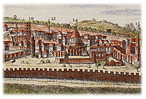
Detail,
A Draught of the City of Jerusalem, Cornelis de Bruyn, 1780
Visit
gallery
|
One of the geographers to
place Jerusalem squarely in the center of the world image was also the first
to create a detailed, empirically based representation of the Holy Land. This
was Petrus Vesconte, a mapmaker whose rendering survives in a work by Marino
Sanudo of circa 1320. The map was used as part of Sanudo's appeal to the kings
of Europe to undertake a new expedition against the Turks; the West's loss of
Tripoli and Acre in 1289 and 1291, respectively, was still a fresh and bitter
memory when the map was made.
The mapping of the Holy
Land was of such importance that the first European printed map based on actual
empirical observation was not of readily surveyed European land but rather of
the Holy Land. It was published in 1475 and was derived from the pilgrimage
of the thirteenth-century Dominican Burchard of Mt. Sion. Furthermore, shortly
afterward, when the maps of the ancient Alexandrian geographer Claudius Ptolemy
were first published, a map of the Holy Land, based on Vesconte's work, was
among the first crop of "modern" maps made to supplement it.
While the explosion in printed
maps in the sixteenth century created a demand for more accurate and detailed
examples, these older sources were not abandoned. Christian van Adrichom (1533
— 1585) produced a map of the Holy Land that endured as the principal prototype
of the region for two centuries, yet even his model owes considerable debt to
both Burchard of Mt. Sion and Vesconte.
|
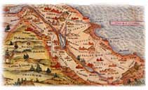
Detail,
The Holy Jewish Land,
Sebastian Münster, 1545
Visit gallery
|
Nor was the biblical significance
of the region lost in the Renaissance. Quite the contrary; the new mappings
of the Holy Land served as a canvas for reconstructing biblical events and better
placing the Twelve Tribes. This is already evident in the map of the Holy Land
from the first methodically conceived, uniformly produced atlas, the 1570 Theatrum
of Abraham Ortelius. That map, based on the contemporary geographer Tilleman
Stella, carefully plots the exodus of the Israelites from Egypt.
Pictorial representations
of biblical events also became an important element in maps of the Holy Land.
Ortelius's Terra Sancta of 1584 is based on geography by Peter Laicksteen and
Christian Sgrooten, sporting different misconceptions from its 1570 predecessor
and showing Jonah being thrown from his ship. Ortelius's Abrahami Patriarchae
Peregrinatio et Vita expands dramatically on the synthesis of cartography and
iconography, flaunting twenty-two finely engraved vignettes illustrating the
life and travels of Abraham. They include Abraham's journey from Ur, his offerings
on the altars at Shechem and Bethel, the birth of Isaac, and the expulsion of
Hagar.
As with printed maps, the
Holy Land provided the makers of printed city views a rich subject with which
to develop their art. The Nuremberg Chronicle of 1493, the first lavishly illustrated
printed book, included three views of the Holy Land — one of the walled
city of Jerusalem, one of Solomon's Temple, and the third, displayed in the
exhibition, depicting the destruction of Jerusalem with the Temple ablaze. When
in 1572 Braun and Hogenberg produced the first atlas of city views, Jerusalem
was their focus three times, including the finely detailed plan of Jerusalem
et suburbia.
These and other early models
for the mapping of the Holy Land and Jerusalem remained the basis for the charting
of the region up until relatively modern times. Despite the emphasis on accuracy
and the quest for improvement in Western mapmaking, it might be said that in
its mapping of the Holy Land, more than any other region, this "scientific"
attitude was always tempered with a reverence for tradition, iconography, and
the past.
|
THE
HERBERT & EILEEN MUSEUM at TEMPLE EMANUEL, NYC
|
|
Congregation
Emanu-El is fortunate to possess a diverse collection of approximately
five hundred pieces of Jewish art objects. Ranging in date from the fourteenth
to the twentieth centuries, the collection includes pieces of Jewish ceremonial
art, household ritual objects and memorabilia reflecting the history of
the Temple. The core of the collection is composed of two major gifts
to the Congregation, one by Henry M. Toch in 1928 and another, consisting
of 150 pieces, by the Judge Irving Lehman in 1945. This distinguished
collection is striking not only for its beauty, rarity and splendor but
for the way it illuminates a notable segment of American Jewish history
and the heritage of an eminent synagogue.
The
Herbert & Eileen Bernard Museum
Located at the Temple at One East 65th St.
Just off 5th Ave. in New York City
|
|